Our Technology
High-fidelity, efficient computer vision technologies
The ever-increasing volume of available image and video data has overwhelmed existing manual or semi-automatic exploitation techniques. Exploitation of such massive amounts of data requires fully automated systems or semi-automated methods—all with minimal human supervision.
VSI strives to develop intelligent, automatic, and robust computer vision technologies based on realistic conditions and extensive testing.
See what our cutting edge tools can do to enhance your practical requirements.
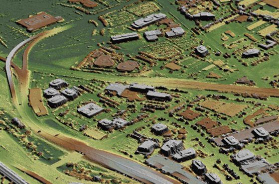
Probabilistic Volumetric Representation
3D modeling using the Probabilistic Volumetric Representation (PVR) enables the representation of inherent ambiguity and uncertainty that may be present in the imagery or other source data. This technology facilitates a fully-automatic reconstruction of high-fidelity 3D terrain models from motion and still imagery of different modalities such as such as EO, LWIR, MWIR, Satellite imagery and LIDAR. VSI has developed several key exploitation and intelligence service applications of this technology, such as visualization of terrain for situational analysis, change-detection, geo-positioning and geo-registration.
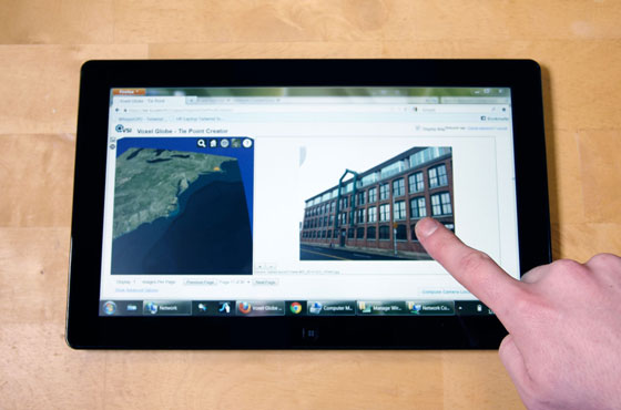
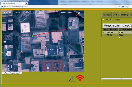
3D GIS Web Services
The 3D GIS is a web-browser based capability to augment real-time situational awareness for tactical and strategic planning. It works across a multitude of devices from mobile clients such as smartphones and tablets to workstations. All information is presented in a browser. No special client software is required. Numerous GIS services can be provided such as Line of Sight Analysis, Mensuration (Length, Area, Volume), Path Navigation and 3D Attribution.
See computer vision in action
Scene Understanding
VSI has developed scene understanding algorithms using belief propagation on probabilistic graphical models which provide a mechanism for a potentially large number of lower-level algorithms to provide feedback to each other and contribute to a high-level 3D scene description. In addition to increasing detection and classification accuracy, this technology provides the groundwork for efficient and intelligent image indexing systems which allow for complex scene content queries..